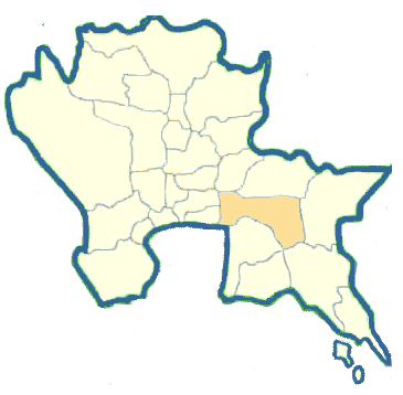
Chachoengsao Province in Central Thailand

Chachoengsao is located on the bank of Bang Pakong River, 24 kilometers upstream from the mouth. It is believed to be a new town established in the Ayutthaya Period around the year 1549 during the reign of King Maha Chakkraphat for armed force recruitment purposes. Chachoengsao town was first found in the historical records during the reign of King Maha Thammaracha when Thailand was in a weakened state due to being defeated by the Burmese. Phraya Lawaek, a Khmer king, saw that it was his good opportunity to locate Thai people to be his work force. He led his army by land and water to enslave a huge number of people from Chanthaburi, Rayong, Chachoengsao and Nakhon Nayok.
Chachoengsao, or as commonly called "Paet Riu", is some 100 kilometers east of Bangkok occupying an area of 5.351 square kilometers. It is a low basin suitable for cultivation, especially rice, which is the economic crop providing the principal income to the province. Chachoengsao is administratively divided into nine Amphoes and two King Amphoes: Muang, Bang Khla, Bang Nam Prieo, Bang Pakong, Ban Pho, Phanom Sarakham, Sanam Chai Khet, Plaeng Yao, Ratchasan, King Amphoe Tha Takiap and King Amphoe Khlong Khuan.
What to see and what to do in Chachoengsao?
Wat Sothon Wararam Worawihan
This monastery houses Phra Phutthasothon or "Luang Pho Sothon". This is a very sacred Buddha image and is most revered by the people. The image in the attitude of meditation has a lap width of 165 centimeters and height of 198 centimeters. Wat Sothon is on the river bank in Amphoe Muang approximately two kilometers south of Sala Klang (the City Hall ).
Legend says that there were three bronze cast Buddha images floating down from Prachin Buri. They appeared at Sampathuan County of Chachoengsao. The villagers, after recognizing the situation, tied the three images with ropes and tried to pull them out of the water but failed. The three images continued floating downstream. The big one later appeared at Ban Laem of Samut Songkhram where the people enshrined him at Wat Ban Laem. The small one appeared and was enshrined at Wat Bang Phli of Samut Prakan. The medium sized one, Luang Pho Sothon, appeared in front of Wat Sothon. The people tried to pull it up from the water but they did not succeed the first time. Then a wise man power built a small shrine for a ceremony paying homage to Phra Phuttha Sothon. They invited him and pulled him out to be enshrined at Wat Sothon as can be currently seen. There are two annual fairs celebrating Luang Pho Sothon. One falls in the middle of the 12th lunar month and the other falls in the middle of the 5th lunar month.
Somdet Phra Si Nakharin Park is located in front of the Chachoengsao City Hall with a total area of about 90 rai. The park is arranged like a local garden with a large swamp in the middle which is surrounded by various types of trees.
Bats at Wat Pho BangKhla
Wat Pho Bang Khla is located 17 km. along the Highway 304 (Chachoengsao-Kabin Buri route) with another 6 kilometers after a turn on Highway 3121 in Amphoe Bang Khla. Thousands of fruit eating bats (or flying foxes) hang in crowds on several big trees within the monastery.
Khao Hin Son Development Study Center
It is on Phanom Sarakham-Kabin Buri Road between Km.51 and 52 near Tambon Khao Hin Son and Tambon Ko Khanun, Amphoe Phanom Sarakham, and occupies an area of 1,929 rai (about 770 acres). Khao Hin Son is a hill having white sandy rocks thickly dotting the landscape. It is one of the beautiful places in Chachoengsao. Within the center are Phra Bowon Shrine, King Phra Pin Klao Monument located in the botanical garden zone, fast growing tree garden zone, crop cultivation experimental plots, fishery and livestock demonstrations and occupational training area at the Special Folk Arts and Crafts Center under H.M.the Queen's patronage. A royal idea of the present king originated the establishment of this Khao Hin Son Development Study Center.
